Friday, November 21, 2008

First Ukrainian MPA

13:58 21 ноября 2008

Акватория Черного моря объявлена государственным заповедником «Филофорное поле Зернова»

Президент Виктор Ющенко объявил природную акваторию Черного моря ботаническим заповедником общегосударственного значения «Филофорное поле Зернова». Об этом идет речь в указе Главы государства от 21 ноября, текст которого есть у «proUA».

Указ выдан «с целью сохранения и воссоздания природной акватории Черного моря, которое имеет особенную природоохранную, научную, эстетичную и познавательную ценность, в соответствии со статьей 53 Закона Украины «О естественно-заповедном фонде Украины».

В частности, площадь ботанического заповедника общегосударственного значения «Филофорное поле Зернова» природной акватории Черного моря будет составлять 4025 квадратных километров с координатами:

45°18’25’’ северной широты и 30°42’26’’ восточной долготы;

45°54’42’’ северной широты и 30°55’05’’ восточной долготы;

46°01’53’’ северной широты и 31°10’40’’ восточной долготы;

45°З1’05’’ северной широты и 31°42’56’’ восточной долготы;

45°17’41’’ северной широты и 31°23’20’’ восточной долготы.

Также Президент поручил Кабинету Министров в трехмесячный срок утвердить Положение о ботаническом заповеднике общегосударственногозначения «Филофорное поле Зернова»; а также передачу акватории, объявленной этим указом заповедником общегосударственного значения, под охрану научно-исследовательскому учреждению «Украинский научный центр экологии моря», которое принадлежит к сфере управления Министерства охраны окружающей естественной среды Украины, с оформлением охранительного обязательства.

proUA

http://proua.com/news/2008/11/21/135826.html

Wednesday, October 01, 2008

AAG 2009 CALL for Marine Geomorph Papers

2009 AAG ORGANIZED SESSION
Marine Geomorphology and Mapping for an Ecosystem-Based Management Approach to Marine Reserve Design and Planning

Seeking co-sponsorship from the Coastal and Marine (CoMa), GI Systems and Science, and Biogeography Specialty Groups

Association of American Geographers Annual Meeting, March 22-27, 2009 Las Vegas, NV, USA

ORGANIZERS:
Dawn Wright, Oregon State University, dawn@dusk.geo.orst.edu Will Heyman, Texas A&M University, wheyman@geog.tamu.edu

DESCRIPTION: These sessions will be a follow-up to the highly successful AAG sessions of 2008 entitled "Marine Geomorphology as a Determinant for Essential Life Habitat: An Ecosystem Management Approach to Planning for Marine Reserve Networks." In 2009 we will continue to present and critically examine the growing body of data suggesting that the underlying geology and geomorphology of marine environments dictates the location of critical life habitat for a variety marine species. The broad implications of these findings suggest that geomorphology might be used as a proxy for (or at least help to identify) critical life habitat for marine species, and thus serve to advance the application of ecosystem-based management (EBM) to the design of marine reserve networks. Our goal once again will be to bring together a group of scholars working on this and related issues, and to further advance collaboration between scientists and marine managers towards more efficient conservation and management of marine systems.

Papers are welcome in the areas of:
- essential benthic habitat and geomorphology
- marine GIS and/or remote sensing for the purposes of integrating geomorphology and biology
- applications for marine reserve network design

These will be combined into at as many sessions as needed and will likely include a final panel discussion.

DEADLINES:
October 14, 2008 (TUESDAY): Submit a PIN to either Dawn Wright or Will Heyman

All participants must first register individually for the meeting. 
Please follow the instructions at http://www.aag.org/annualmeetings/2009/registration.htm. Upon registration you will be given a participant identification number (PIN). Send this PIN and a copy of your final abstract to Will or Dawn. They will not edit your abstract, nor will the AAG, so please make sure it is grammatically correct and without typos.

October 16, 2008: Sessions submitted to the AAG for approval.

March 22-27, 2009: AAG Meeting in Boston. Exact day and time of  sessions to be announced.

Postdoctoral Position in Paleoclimate Research

IMPERIAL COLLEGE LONDON
Department of Earth Science and Engineering
Postdoctoral Position in Paleoclimate Research
Applications are invited for a Research Associate to work on the reconstruction of deglacial Atlantic Ocean ventilation rates, funded by the Natural Environment Research Council, under the direction of Dr Tina van de Flierdt (Imperial College London). The position is available to start on or before 1 April 2009.

Deglacial Atlantic Ocean Ventilation Rates
Ocean
ventilation rates are closely linked to climate change through the formation and convection of deep waters. Since the deep ocean contains most of the carbon in the ocean-atmosphere system, ventilation rates exert an important influence on climate via the greenhouse connection. Knowledge of the ventilation rate in the modern and the past ocean is therefore a key parameter in understanding the carbon cycle and climate change. Within the proposed project, ocean ventilation rates for the deglacial Atlantic Ocean will be reconstructed using paired radiocarbon and Nd isotope measurements on U-Th dated deep-sea corals.

The successful candidate will have a PhD in paleoclimate, paleoceanography, isotope geochemistry, or closely related subject areas. Good laboratory skills are highly desirable and candidates with experience in clean room chemistry and mass spectrometry are particularly encouraged to apply. You will join an international collaborative project with Dr Laura F Robinson (WHOI) and Professor Jess F Adkins (Caltech). Your work will focus on the radiogenic isotope geochemistry of deep-sea corals and will be carried out in the new isotope geochemistry facility of the Earth & Planets Section of the Department of Earth Science and Engineering at Imperial College London. The department has close ties to the newly opened Grantham Institute for Climate Change offering a multidisciplinary and stimulating environment for paleoclimate research.

Further information can be obtained from Tina van de Flierdt, tina.vandeflierdt@imperial.ac.uk.
Application forms and further details of the post can be downloaded from http://www3.imperial.ac.uk/employment/research.

A completed application form, a curriculum vitae, brief statements of research with the names and contact details of at least two referees, should be sent to Darakshan Khan, email: d.khan@imperial.ac.uk,. Please quote PDRA/TvdF/corals in all correspondence.

Closing date: 30 October 2008

Monday, September 29, 2008

Jobs at NIVA - Norway

The Norwegian Institute for Water Research needs more scientists in the field of ecological modelling. We need biologists/ecologist, preferably in the marine field, with good skills in statistics and ecological modelling. Knowledge of spatial predictive modelling of terrain, species and habitats is desired, but not required. Knowledge of different GIS tools (e.g. ArcView/ArcGIS, Spatial Analyst, R-packages for spatial prediction) is essential, and experience in satellite and aerial imagery analyses is an advantage. The applicant should have a PhD and/or experience with applying for and managing research projects.

If you know of someone, please forward this e-mail and tell them submit and application and CV by October 16.

Read more about NIVA at www.niva.no (only in Norwegian), and contact Trine Bekkby (trine.bekkby@niva.no) if you have any questions.
--------------------------------------------------------------------------

Friday, September 26, 2008

Vacant position - Submarine nature type/habitat mapping, Geological Survey of Norway

Submarine nature type/HABITAT mapping - Geological Survey of Norway


At the Geological Survey of Norway, a 1-year position in marine nature type mapping is vacant in the Marine Geology team, starting immediately.


The position will be linked to the MAREANO programme (www.mareano.no) and various research projects in which nature types and ecosystem based management are key elements.


The Marine Geology team comprises a group of ten scientists and four engineers. The members of the team work within a wide variety of geological fields in the coastal zone and on the continental shelf and slope. Documentation of the importance of geological data for ecosystem based management and geological studies for the petroleum industry are central tasks. NGU has a strong focus on digital databases, which are made available on the internet.


We are looking for a highly motivated scientist (MSc/PhD) experienced in some or all of the following areas:


·         Digital processing and interpretation of marine geological and multibeam bathymetric data using commercial and non-commercial data programs.

·         Nature type/habitat mapping to study and document the relationship between geology and biology on the seabed using GIS-analyses and multivariate statistical analyses.

·         Field investigations combined with ecological modelling -  the candidate will be working in a multi-disciplinary environment, e.g. together with biologists from the Norwegian Institute of Marine Research.


Experience from research cruises and data collection (seismic, multibeam bathymety, seabed sampling) would also be useful. The candidate will be involved in compilation of digital products and descriptions, presentation at scientific meetings, and publishing of scientific results in international journals.


NGU encourages applications from female scientists. We can offer a favourable working environment, scientific challenges and good possibilities for participation at international meetings. A kindergarten is run by and for NGUs employees. Salary is dependent on qualifications and experience.


Further information about the position can be obtained from Project Leader Terje Thorsnes (terje.thorsnes@ngu.no), Team Leader Reidulv Bøe (reidulv.boe@ngu.no) or Director of the Earth Science Department Øystein Nordgulen (oystein.nordgulen@ngu.no).


Applications, including CV, reprints, and the names and addresses of three professionals who may be contacted for reference should be submitted on www.ngu.no/stillinger by October 20th 2008. We would like the successful candidate to start as soon as possible.


Saturday, September 13, 2008


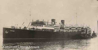
6 Sept 2008 the oceanographic survey ship USNS Pathfinder, under Military Sealift Command, started searching in Ukrainian territorial waters for the SS Armenia, sunk in 1941 by the German Luftwaffe, one of the world’s most powerful air forces at the time. The World War II Soviet-flagged hospital ship was sunk with 7,000 people on board. The high-tech, 328.5-foot-long Pathfinder must scour murky waters for one shipwreck among many at depths ranging from 100 meters to 1,000 meters. Scientists will use a side-scan sonar and multibeam sonar. If sonars indicate a possible wreck, a remotely operated vehicle with video capabilities will be used to verify findings.

Here is info about SS Armenia from this site: http://forum.axishistory.com/viewtopic.php?t=78290

“Armenia” was the main hospital ship of Black Sea Navy during WWII, having 119 men of medical staff in addition to the regular crew. It made near 15 runs and evacuated more than 15000 people. “Armenia” was sunk on 6 November 1941 near Aj-Todor cape (depth 450 m). Approximately 7000 wounded men, civilians and almost all evacuated medical staff of Black Sea Navy were killed during the bombing of “Armenia” by German bombers – that was the largest catastrophe on Black Sea, with only 8 men survived. That was a very mysterious catastrophe – despite the fact that there were several another hospital ships in the port, the captain of “Armenia” received the order to take all medical staff from the hospitals of enclosed Sevastopol, also many officials from the evacuated organizations in addition to thousands wounded men. Destroyer and many patrol ships should have escorted the overladen “Armenia” for good AA defense, but at the last moment the captain of “Armenia” received the order to start on its last journey only with two small patrol boats.

the pictire of SS Armenia comes from http://www.riverstar.ru/albums/album15/Armenia_m.sized.jpg

Details of the sinking here in russian:
http://www.newsru.com/world/05may2005/ship.html

Multibeam on your car

Lincoln will sell the Ford Flex-based MKT crossover next year after a January Detroit show reveal. It will come in six- or seven-passenger variants and will add a plethora of high-tech conveniences, including Blind Spot Monitoring and Cross Traffic Alert System. The latter uses two multibeam sonar modules in the rear quarter panels that alert the driver with an indicator light on the corresponding outside mirror when another vehicle enters the blind-spot zone.
http://www.motortrend.com/future/future_vehicles/112_0811_lincoln_mkt_confirmed_mkz_refreshed/index.html

Friday, September 21, 2007

Geoscience Australia - Benthic Marine Ecologist (Ref: 11817)

Role Description: The Prediction and Management of Marine Biodiversity Project is seeking a motivated and enthusiastic research scientist to investigate the degree to which marine biophysical data can be used as surrogates of marine benthic habitats and marine biodiversity. The position forms a key component of this multidisciplinary project, which comprises a team of marine scientists based at Geoscience Australia and partners at CSIRO, the University of Tasmania, AIMS and the Museum of Victoria. The outputs of the project will be used to support the sustainable management of Australia’s marine environment. This position is available immediately for a period of three years.

Role Duties: 1.Conducting innovative research into biophysical variables useful as surrogates of benthic habitats and for the prediction of patterns of biodiversity; 2.Apply/develop statistically robust methods for comparing abiotic variables with the distribution of marine biota over a range of spatial scales in both shallow- and deep-sea environments; 3.Developing new and/or applying existing methods to extract biological information from underwater video footage and sediment samples of the seabed; 4.Writing scientific publications and technical reports in conjunction with other project scientists; and 5.Disseminating research outcomes at forums and conferences.

Special Requirements: •Relevant tertiary qualifications, PhD or equivalent, in benthic marine ecology, biology or geology, and/or a related field of marine science. •Experience in the statistical analysis of benthic marine ecological data is a pre-requisite. •A record of peer-reviewed scientific publications in marine ecology, geology or other appropriate field; •Experience in spatial science/GIS; •Experience working effectively as part of a small team to achieve project outcomes; •Experience or expertise in marine geoscience is highly-desirable.

Key Relationships: The position will be located within the Marine and Coastal Environment Group of Geoscience Australia. You will report to the Project Leader of the Marine Biodiversity Hub Project, and work closely with CERF Hub partners at CSIRO Marine and Atmospheric Research in Brisbane, University of Tasmania Hobart, AIMS Townsville and Museum of Victoria, Melbourne. Internal: Application Support and Product Development, Labs, Sample repository External: Marine and Biodiversity Branch of Department of Environment & Water Resources, CSIRO, AIMS, UTAS, Museum of Victoria, APPEA, AMSA, WWF.

Additional Details:

Geoscience Australia Band / Level: Band 2 Level 4 (APS 6)

Division/Branch: Petroleum and Marine Division

Specified Task Duration:: 3 Years

Specified Task:: To investigate the degree to which marine biophysical data can be used as surrogates of marine benthic habitats and marine biodiversity.

Salary Band: Band 2 Level 4 – from $66,055 to $73,520

Employment Type: Full Time


Security Level: Protected

Functional Stream: Scientific

Project/Section: Marine & Coastal/ CERF

Shortlisting Question One:

Selection is competitive, and will be on the basis of an assessment of candidates’ work-related qualities and those required for performance of the duties, as well as the capacity to achieve outcomes related to the duties, as reflected in the Role Profile.

For short-listing purposes, please tell us about your experience in using statistical methods to determine relationships between benthic biota and physical variables, or similar related work. Please also document your experience working as part of a team that is relevant to this position.

It is in your interest to relate your statements, as far as practicable, to the requirements of the job as set out in the Role Profile.

Contact Officer: Brendan Brooke

Contact Officer Phone: 02 6249 9434

Contact Officer Email: Brendan.Brooke@ga.gov.au
Thursday, September 20, 2007

BIO open house

Experience Hands on Marine Science at the Bedford Institute of Oceanography Openhouse

The Bedford Institute of Oceanography in Dartmouth, NS is making waves as Canada’s largest centre for ocean research and they want you to discover the fascinating world of marine science. Come tour a Coast Guard ship, uncover the mysteries of the Halifax Harbour or touch some ocean critters at the BIO Open House, October 20-21st. For more information contact Claudia Currie at ccurrie@nrcan.gc.ca or visit www.bio.gc.ca